In the mid/late 1950’s my friend and I used to have a job after school helping to collect ‘Bag Wash’ for the Tilbury Laundrey.
We would go to the Dwellings collecting Bag Wash from the doorsteps and throw it over the balcony to be collected by the driver below.
It was great fun at the time but probobly quite dangerous if someone had been walking by.


Comments about this page
Add your own comment
My
Mother in law was related to May Tyndall and May was my
Mums best friend x
When was this building erected? I have family on the 1891 census living at Tilbury Dwellings, Southend Row, Chadwell St Mary. Is this the same address you are talking about? The father John Henry Pinner is a lock keeper.
Can anyone tell me who used to live at 44 Sydney road tilbury essex in 1914/15 my father was born there was it a dwelling house ?
Thanks Cliff, It wouldn’t be the first publication (official or otherwise) to get the spelling wrong. The road sign was just outside my mum and dads bedroom window.. and my dad a very light sleeper, so I doubt they’d have got away with it Lol!
Cliff, sorry I should have said, great map by the way.
Hi Mark
There is a map dated 1920 on the Essex Record Office website spelling the name Peninsular http://www.essexrecordofficeblog.co.uk/tag/tilbury/
Perhaps the vandals had pinched the letter ‘R’ off your road sign!
Always interesting to read about my old home town, and in particular my part of it. I don’t want to appear pedantic but purely in the interests of history and to keep the record straight, Peninsular is part of the name of the large shipping and ferry company, Peninsula was the name of the road I lived in.. living right on the corner we even had the road name sign on our wall! I hope I don’t come across as small minded but I like to keep the facts correct. Interesting post by the way.
My guess is the photographer is standing in St. Andrews Road with his back to the Docks and his right shoulder pointing towards the hospital.
I would be interested to know where the photograph at the head of this page was taken. Having studied my 1970 map again, and looked at the aerial photo of the docks in my book “Grays Thurrock” by Barry Barnes, my best guess is that the photo above was taken looking west from the junction of Ferry Road and Orient Road. On my old map, Chapel Road is 2mm long, and Orient Road is 5 – 6mm long,slightly longer on the south side of the road. That would mean that Orient Road was 2 to 2 1/2 times longer than Chapel Road. If, as I still believe, there were tall buildings on Chapel Road, that road would not have been long enough for more than one block building on each side of the road.
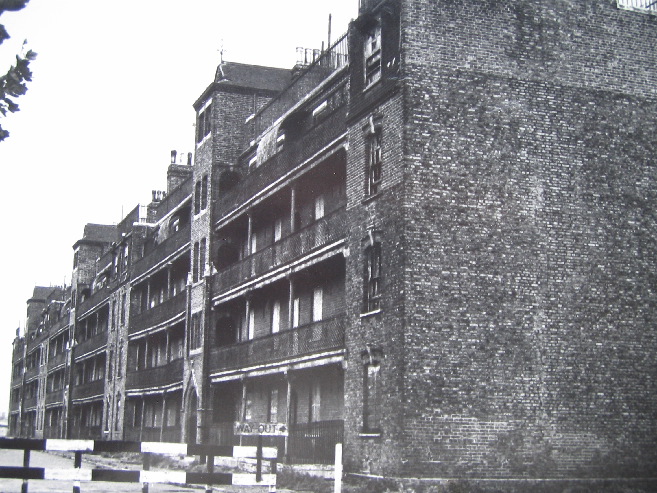
Living now in Cardiff, I have traced a local business that can do photographic enhancement on old pictures. I’m hoping it will clarify whether there were buildings on Chapel Road in the 1920s, which would have been the “stopper” in the Bottle shape formed by the galleried dwellings flats clearly shown on StAndrews Road, Orient Road, and Ferry Road. Of course, even if it can be proved that there were no Chapel Road dwellings in the 1920s, it doesn’t necessarily mean that there weren’t any later on. The photograph above, plus picture number 150 in my book, are the only two photos I have seen of the dwellings with open galleries/walkways, and taken from street level.
If Orient Road was 2 1/2 times longer than Chapel Road, and Ferry Road and StAndrews Roads were 3 1/2 times longer from Chapel Road to Orient Road, it’s logical that far fewer people could ever have lived in Chapel Road. So, how likely is it that there are any undiscovered photos of buildings on Chapel Road? I think the answer is, pretty unlikely.
Still, I can but hope. (It’s part of this old man trying to reconnect with his past, and isn’t that what “Tilbury and Chadwell Memories” is mostly about?
I have just put on a page ‘Docking of the Jervis Bay’ http://www.tilburyandchadwellmemories.org.uk/page/docking_of_the_jervis_bay and on the link to the Essex Record Office http://www.essexrecordofficeblog.co.uk/tag/tilbury/ there is a map of Tilbury dated 1920. It clearly shows the Dwellings, Railway Cottages , Peninsular Road, Orient Road and part of a road which appears to be Chapel Road that Roger has been referring to.
Hi Percy, the only reason I refer to flats on Chapel Road is because that is the name given on my map,which the publishers say was based on HMSO maps. Maybe the buildings I thought I saw were further south on Orient Road. I would probably never have had more than 10 to 15 seconds view. And as I said, it was a lifetime ago, so you’re probably right. In the end, it doesn’t matter – the hospital, dwellings, and Chapel, Orient and Peninsular Roads are all gone; I don’t suppose it’s very likely that these names will reappear.
Roger,
I was born in the Dwellings and brought up in the Railway Cottages and as I mentioned previously lived in Tilbury from 1948 until 1970. I am well acquainted with the small link road between Ferry Rd and St Andrews Rd as I passed it daily, certainly throughout my school life. As far as I can recall there was never any street sign declaring that it was Chapel Rd and to my recollection I have never once heard it referred to as Chapel Rd, even by any of the older folk of the day but I guess you live and learn.
Regarding tall buildings facing one another across Chapel Rd I think this must be a figment of your imagination because in my memory the only tall structure that remained in that area after the Dwellings were demolished were the flats in Orient Rd. This was the building that housed the PLA police club on the ground floor next to the entrance.
Hi Percy, I have an old map of “Grays and Tilbury”, dating to 1970, by G Barnett and Son Ltd, which claims to be “based upon the Ordnance survey by permission of H.M. Stationery Office.” So I would hope that is an accurate record of how Grays, Tilbury, Orsett, Stifford, Little Thurrock and Chadwell St. Mary were, 45 years ago.
On my map, Chapel Road was a short road, maybe half the length of Orient Road, which connected Ferry Road to the East, and St Andrews Road to the west. If you came down the hairpin bridge between the railway line and the docks, you would have turned right onto Chapel Road, at the base of the ramp.You would have been looking towards the Main Dock, and the then East Branch Dock, which was slightly to the north. East branch dock was where I remember seeing the P and O liners Chusan and Oronsay moored during the 1960s.
Does anyone remember the two tall buildings which faced each other across Chapel Road? I remember seeing them from the railway line, between September 1962 and July 1967. They seemed much taller than any other buildings; given that the dwellings flats on the west side of Ferry Road were destroyed in world war two, and the dwellings flats on St Andrews Road were demolished in 1961, there wouldn’t have been any other high rise buildings nearby. I don’t think the Chapel Road flats(?) had any galleries with railings, like the pictures of the older dwellings flats on Orient Road, Ferry Road and St Andrews Road. Desperate to see pictures of the Chapel Road flats, I did a Google Earth search, but nothing came up. Just to make sure, I bought a Grays Thurrock A to Z street atlas published 2010.
In answer to your question Percy, Chapel Road no longer exists. Peninsular Road and Orient Road have also gone, as have the hairpin bridge and the old Tilbury Hospital. I am particularly sad about the hospital,which was built earlier than 1924 by the Seamens Hospital charity (long before the NHS was set up in 1948). My late father had treatment there during the late 1950s or the 1960s – I can’t remember which, it was such a long time ago.
Can anyone help with pics of the Chapel Road flats? (I wonder if they were built during or after WW 2 to replace housing lost to bombing.)
Hope this helps, Percy.
I lived in Tilbury from 1948 until 1970 and I’ve never heard of Chapel Road, where is it or where was it?
I have a book called “Grays Thurrock” by Barry Barnes, published by Phillimore, which I picked up secondhand on Ebay. Picture number 166 is described as “a rare early aerial photograph showing Tilbury Dock in the early 1920s”.
It clearly shows Tilbury hospital, with a “square” of semi detached houses between Peninsular Road and Orient Road.
To the north side of Orient Road is a triangle of the dwelling flats, enclosed by StAndrews Road on the west, and Ferry Road on the east. The gallery walkways of the flats on St Andrews road can be seen, though the quality of this old black and white photo is not too great by today’s standards.
The picture clearly shows the old hairpin bridge; at that time, there was no trace of any buildings on Chapel Road, which I reckon were standing there during the 1960s.
Picture number 150 shows dwellings flats, with their galleries and railings. The caption states that they were demolished in the 1950s. From information on this website, that would seem to be incorrect.
Picture 141 shows one of the semidetached houses in Peninsular Road, which would have been to the north of Tilbury hospital. Picture 140 shows part of the hospital, and states that a new ward had been built for “Indian patients.”
What, apartheid in 1920s England? How times have changed!
I hope this info is helpful for visitors to this site.
My great-grandparents lived here with my grandfather who was only one year old when they moved from Lincolnshire to number 128. My great-aunt was born here. The family had moved back to Lincolnshire by the 1911 census. I would love to see more pictures from around 1901 if any one has any.
Hi Claire,
As I remember it we used to cross the Hairpin Bridge and the Dwellings block was in Ferry Road next to the Docks. I only remember the block shown in the picture above which I think was demolished in the early 60’s.
I think there used to be a second block of Dwellings which were destroyed during WW2.
can anyone tell me exactly where the dwellings used to be.
A very happy hunting ground for my brothers and I, to think we’d often play up on the roof of the wash houses..right at the top, doesn’t bear thinking about the outcome had it gone wrong. I recall vividly the BBC team with Fyfe Robertson of the ‘Tonight’ programme turning up one day to interview an old tenant, I can’t recall his name now, but he’d flatly refused to move as the dwellings were being demolished..he did eventually of course, and we enjoyed watching it later on tv.
My husbands grandparents, May and Laurie Tindale lived in the dwellings from 1924-1930 at no 64 on the top floor, she used to tell us stories of getting into trouble for forgetting to empty the copper and clearing the ashes from the boiler on her allotted washing day. She said there was always great camaraderie, the only things she didn’t like about living in the dwellings was the shared toilet and the plagues of black beetles they had to suffer all the time. She and Laurie were eventually rehoused to Shaw Crescent, then Burns Place, where they lived for many years, until moving to Chadwell.
Add a comment about this page