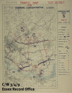
D-Day Map
Tilbury marshalling areas

D-Day assemby areas
ERO
The ERO document of the month for June, 2014 (the 70th anniversary of D-Day) is a map showing the marshalling areas in Tilbury and Chadwell for troops and vehicles on there way to the Normandy beaches.
There is more about the map and its significance in the ERO blog.
Click on magnifying glass icon to enlarge the map.


Comments about this page
Add your own comment
A good day to revisit this posting, 75 years on, and remember!!
I would have been nearly five at the time, and lived in Stephenson Avenue. Seem to recall the Daisy Field being a marshalling area for all sorts of vehicles and armaments, much of it covered in protective material which looked and felt like plasticine. Many of the soldiers threw their “small change” to the children who lined St. Chads Road as the procession of vehicles, including tracked Bren gun carriers, moved towards the Docks. Such excitement for a youngster, with no idea of the horrors that lay ahead for these soldiers.
I remember US Army trucks rumbling along St. Chads Road, heading for the Docks, it must have been around this time. For many of us Tilbury kids it was our first introduction to Messrs Wrigley and Hershey, as the troops tossed out their rations of gum and chocolate bars to us. The troops were presumably on their way to the Utah and Omaha beaches!!
Add a comment about this page